Whenever some state joins the so-called “EU”, state propaganda proclaims it as “joining Europe” although every single one of them lies on a territory that has been part of Europe for millions of years. Whenever the so-called “EU” is mentioned, again the platitude of “united Europe” arises, the idea that the so-called “EU” is the same as Europe. The truth is that the area of the so-called “EU” is just 41.58% of the area of Europe, and that the population of the so-called “EU” is just 59.59% of the population of Europe.
On the other hand, even if it encompassed the whole of Europe, it still would not represent a proper united Europe. Why? Because its members are states, haphazard political and military organisations that rule a certain territory, instead of logical socio-natural units defined by its people(s) and geography.
The major proof of that are regions that at the moment are occupied by two or more states, regions butchered by arbitrary borders that do not take into consideration the natural, ethnological and sociological unity of such regions. There is a multitude of them in Europe, I will mention just some.
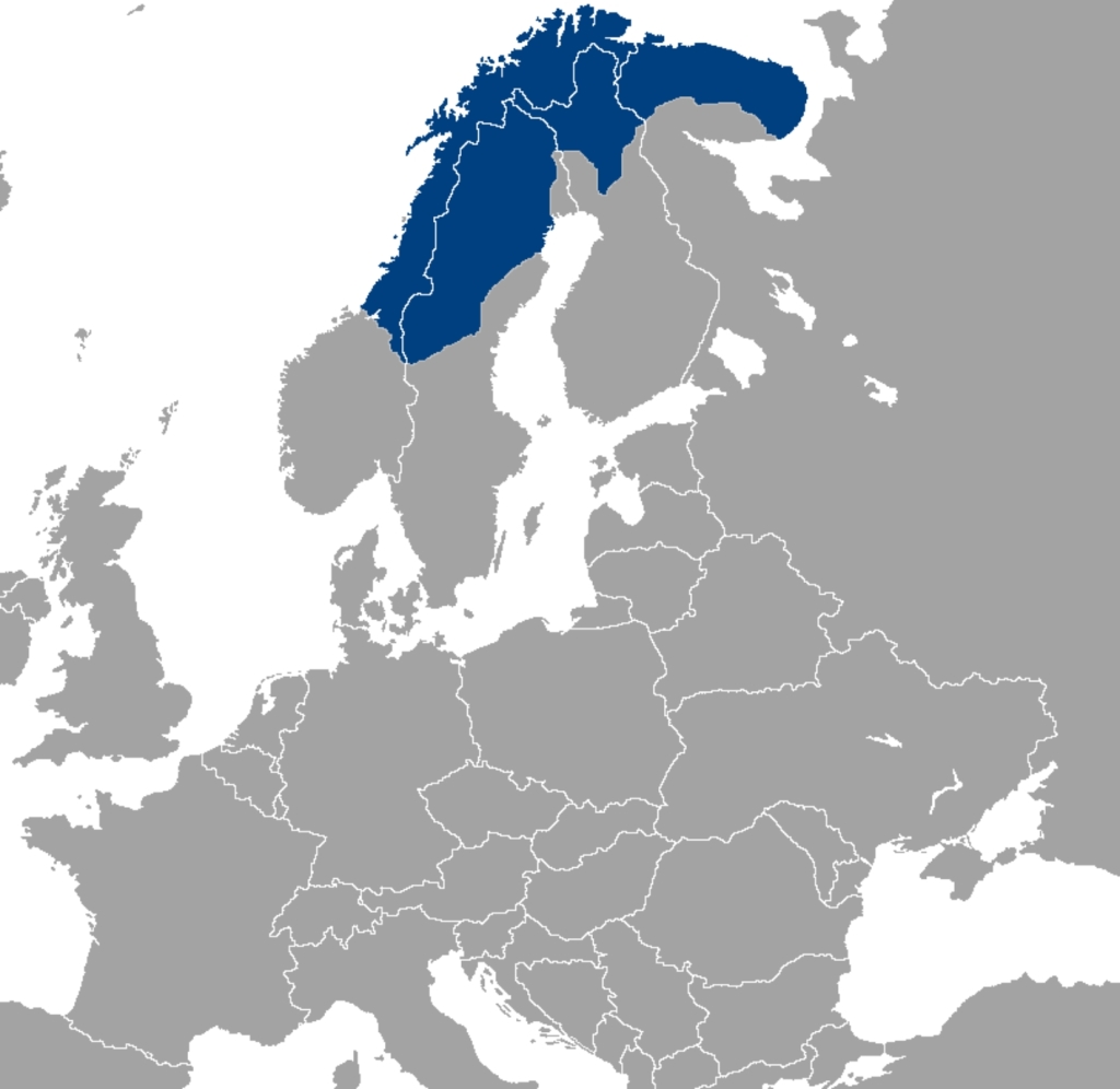
At the very north of Europe Sápmi is divided between four states: Norway, Sweden, Finland, and Russia. Its traditional dwellers, the Sámi, are neither Norwegian, nor Swedish, nor Finnish, nor Russian. They speak Sami, a language belonging to the same Uralic family as the Baltic Finnic ones south of them (Finnish, Estonian, Karelian and others) as well as the more distant (geographically speaking) Ugric languages (Hungarian, Khanty and Mansi) and the Samoyed ones. Their ancestors moved into their present homeland some time after the beginning of the Common Era. Living under different regimes, attending different schools, being subject to different laws, being denied rights to their beliefs, language, land and to the practice of traditional livelihoods, it is no miracle that they suffered (and still do) the cultural consequences of language and culture loss. Add to all this cultural and environmental threats, including: oil exploration, mining, dam building, logging, climate change, military bombing ranges, tourism and commercial development and you have the entire picture what living under foreign states means.
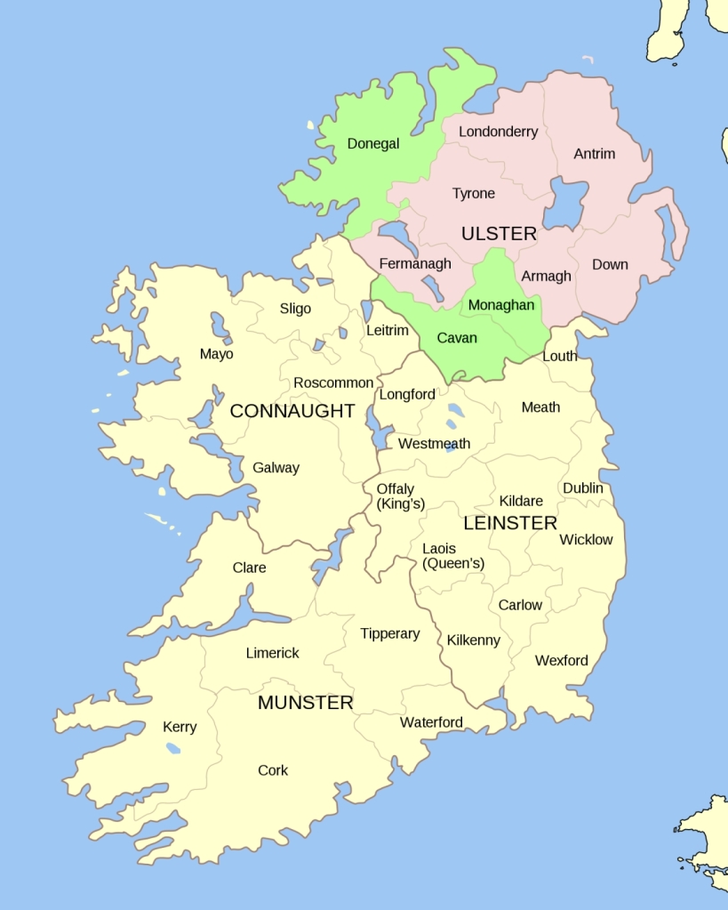
Ireland was traditionally divided in five provinces, four of them existing to this day, Connachta in the West, an Mhumhain in the South, Laighin in the East and Ulaidh in the North, while the central province Mide is today Mí, one of the counties of Laighin. Every province is then divided in traditional counties, a total of 32 of them. After the liberation of the country from British rule in 1922, six counties of Ulaidh, Aontroim, Ard Mhacha, Doire, an Dúin, Fear Manach and Tír Eoghain, have seceded and voted to remain part of the UK, while three of them, an Cabháin, Dún na nGall and Mhuineacháin, remained in Ireland. We all know how many problems this partition engendered. However, partitioning a former colony was a favourite modus operandi of the UK ensuring troubles in the vein of “you see how much better you were under our rule”[1].

Back to the mainland, between Denmark and Germany there is a region with several names in several languages, reflecting the peoples that live there, in Danish it is Slesvig, in North Frisian Slaswik, in Low German Sleswig, and in German Schleswig. Historically speaking, the region, then a duchy, was never part of the German Confederation, an association of 39 predominantly German-speaking sovereign states in Central Europe, created by the Congress of Vienna in 1815 as a replacement for the former Holy Roman Empire, dissolved in 1806, but a fief of Denmark. In the nationalistically charged 19th century, when many nations were invented out of thin air with appropriate national states and national languages, both Danish and German liberals wanted the region to be part of their national state. This struggle caused two wars, the First Schleswig War, caused by the uprising of German speakers in March 1848, and ending in 1852 with a victorious Denmark diplomatically supported by the great powers, and the Second Schleswig War, began in 1864 when the heir to the Danish throne turned out to be unacceptable to the German Confederation, and ending the same year, after which three duchies, Schleswig, Holstein and Saxe-Lauenburg, were governed jointly by Austria and Prussia to become part of Prussia in 1866. After two referendums in 1920, the region was divided between the two states.

Following the coastline to the South-West, we arrive to the Bay of Biscay. There in the angle between France and Spain, another region lies divided, Euskal Herria, homeland of the Euskaldunak speaking the Euskara language. The language is an isolate, it is not related to any known language, present or past. Most hypotheses of its affinity with other languages either lie in the domain of pseudoscience or are controversial. The same can be said for the origin of the people. Some genetic analyses prove them to be cognate with the rest of the population of the area, while others trace their ancestry in Neolithic farmers. Anyway, the land has remained somewhat isolated from the political turmoils surrounding it and the people preserved their language and customs. The fight for their independence has a long history, but has become extremely militant under Franco’s fascist dictatorship, when the region has been subjected to repression, havoc and unrest. This resulted in the founding of Euskadi ta askatasuna (Basque Country and Freedom), better known by its initials ETA, who turned to the systematic use of arms as a form of protest in 1968.
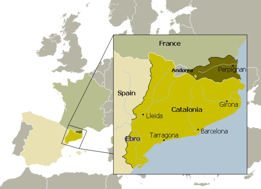
Moving around the Iberian peninsula we arrive to Catalunya, another victim of Franco’s persecution. Although today it is one of the provinces of Spain, historically and linguistically it extends over the border into France. Although France is notorious for its treatment of ethnic and linguistic minorities, it is the Spanish Catalonians who dream of a free state of their own. The reaction of the present Spanish government to this aspirations demonstrated that not much has changed since the bloody days of Franco’s dictatorship, fascist ideas still thrive: tyranny, terror, violence, repression, arrests, nothing has changed.
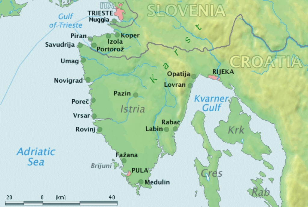
Still in the Mediterranean, in the North-West angle of the Adriatic Sea lays its largest peninsula, Istra/Istria. During its history it was part of various states, beginning with the Roman Empire occupying the land of the Histri, and followed by the Republic of Venice, the Habsburg Empire, the Napoleonic Illyrian Provinces, the Austrian Empire, Italy and Yugoslavia. A land of several languages, Istro-Romance, Istro-Romanian, Istro-Venetian, Chakavian, Slovene,… It represents a mix of cultures not only in an ethnic sense, but also as a land that is both sea- and soil-oriented, a feature not so frequent on the eastern coast of the Adriatic. The present borders were drawn after WWII. In 1945, to avoid a possible conflict between the Yugoslav and Western Allies troops in a region claimed by both Italy and Yugoslavia. A demarcation line was set between them, called the Morgan line, named after Lieutenant General Sir William Duthie Morgan, chief of staff to Field Marshal Sir Harold Alexander, Supreme Allied Commander in the Mediterranean. The line divided the territory into two zones, Zone A in the North-West and Zone B in the East and South, which contained the major part of Istria. In 1947 the border between Italy and Yugoslavia was established while a part of the territory remained independent as the Free Territory of Trieste, it too divided into two zones, separated by the Morgan line. In the end the Venesia Julia/Vignesie Julie/Julijska krajina and the part of the Free Territory of Trieste west of the Morgan line became part of Italy, while the rest of it remained in Yugoslavia. Today, most of Istria is under the Republic of Croatia, a smaller part under Slovenia, and just a tiny bit (Muja and its surroundings) belong to Italy.[2]
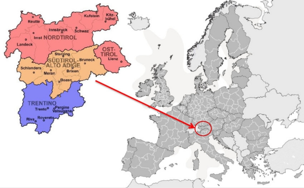
Not far from it there lies Tirol. Today the discontinued North and East Tirol are a Land of Austria, while South Tirol, called Trentino‒Alto Adige, belongs to Italy. After the decline of the Western Roman Empire, Tirol became part of the Ostrogothic Kingdom in 476. After that kingdom collapsed in 553, the Lombards established the Duchy of Tridentum in south Tirol, while Slavic peoples, who had recently taken Carinthia, settled in east Tirol. It was not until the Holy Roman Empire that Tirol was more or less united in 1027 under the rule of the Duchy of Bavaria to be later established as the County of Tirol as a state within the Holy Roman Empire. Finally it came under the Habsburg rule in 1369. Tirol was of great strategic importance to the Habsburgs because it controlled several important Alpine passes and provided a connection to their western landholdings. After WWI, South Tirol and Welschtirol were bestowed to the Kingdom of Italy according to the 1915 secret London Pact and the Treaty of Saint Germain, While Osttirol and Nordtirol remained an unconnected Land of Austria.
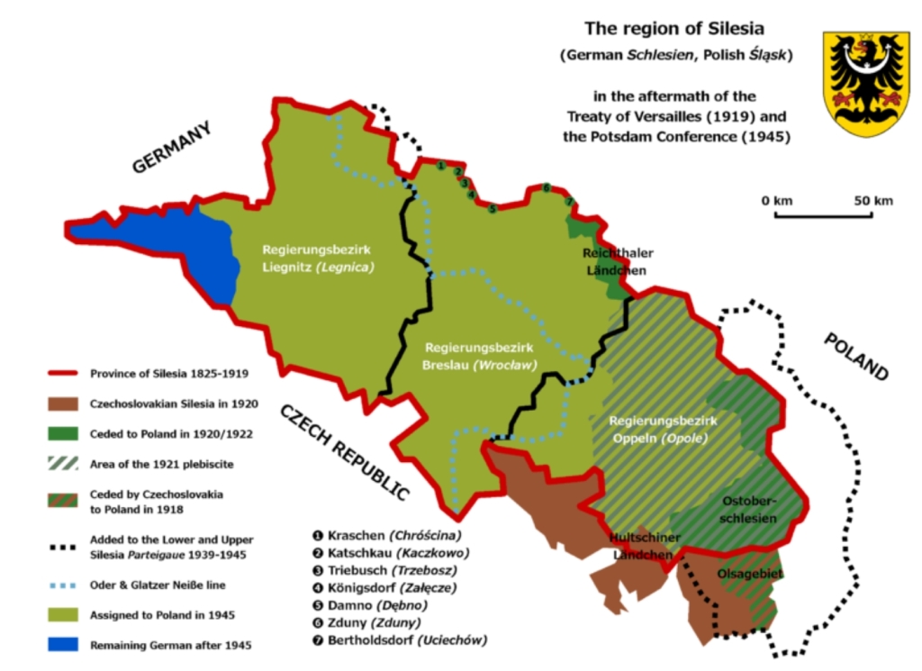
Here we come to another region with a plethora of names by virtue of the ethnic populations that live there, Ślōnsk in Silesian, Śląsk in Polish, Schlesien in German, Slezsko in Czech and Schläsing in Lower Silesian. The first states that are known to have occupied the region were the Slavic ones of Greater Moravia and Bohemia. The region has become part of the Polish state in the 10th century. During the fragmentation of Poland in the 12th century, the land was divided into many smaller duchies ruled by various dukes. Immigration from the Holy Roman Empire increased the German cultural and ethnic influence in the region. After the Mongols have raided it (and the rest of Eastern and Central Europe) in the 13th century, the province became part of the Bohemian Kingdom, itself a part of the Holy Roman Empire, but some duchies remained under the rule of the Polish dukes. In 1526 both the Bohemian Crown and Silesia were passed to the Habsburgs. After that, parts of it were pinched by this or that neighbour, until it came under Prussia in the War of Austrian Succession and subsequently part of the German Empire. After WWI, parts of Upper Silesia were awarded to Poland, the Prussian province was divided in two, and the Austrian Silesia was awarded to Czechoslovakia. The establishment of the Oder-Neiße line as the new border between Germany and Poland fixed the present state, where the majority of the region belongs to Poland, while two smaller portions are parts of Czechia and Germany.[3]

After a series inter-Germanic squabbles in the region following the fall of the Western Roman Empire, Slavs moved into these lands in 600 and founded the Principality of Carantania, assimilating the remaining Celto-Roman population. In 743, prince Borut asked the Bavarian duke Odlio for help against the Avars. The price was Bavarians taking over the region. The territory was incorporated into the Carolingian Empire and later became part of the Kingdom of East Francia. In 976 Carinthia was the first newly created duchy of the Holy Roman Empire. It became part of the Habsburg lands in 1335. After WWI, representatives of the German-speaking territories of Austria in the Reichsrat met in Vienna and agreed that German-Austria should not include “Yugoslav areas of settlement”, as they called them, Lower Styria and two Slovene-speaking Carinthian valleys south of the Karawanken range, Jezersko and Meža valley.[4]

The history of Styria follows that of Carinthia until 1180, when it became a duchy of its own. After WWI, representatives of the German-speaking territories of Austria in the Reichsrat met in Vienna and agreed that German-Austria should not include “Yugoslav areas of settlement”, as they called them, Lower Styria and two Slovene-speaking Carinthian valleys south of the Karawanken range, Jezersko and Meža valley.
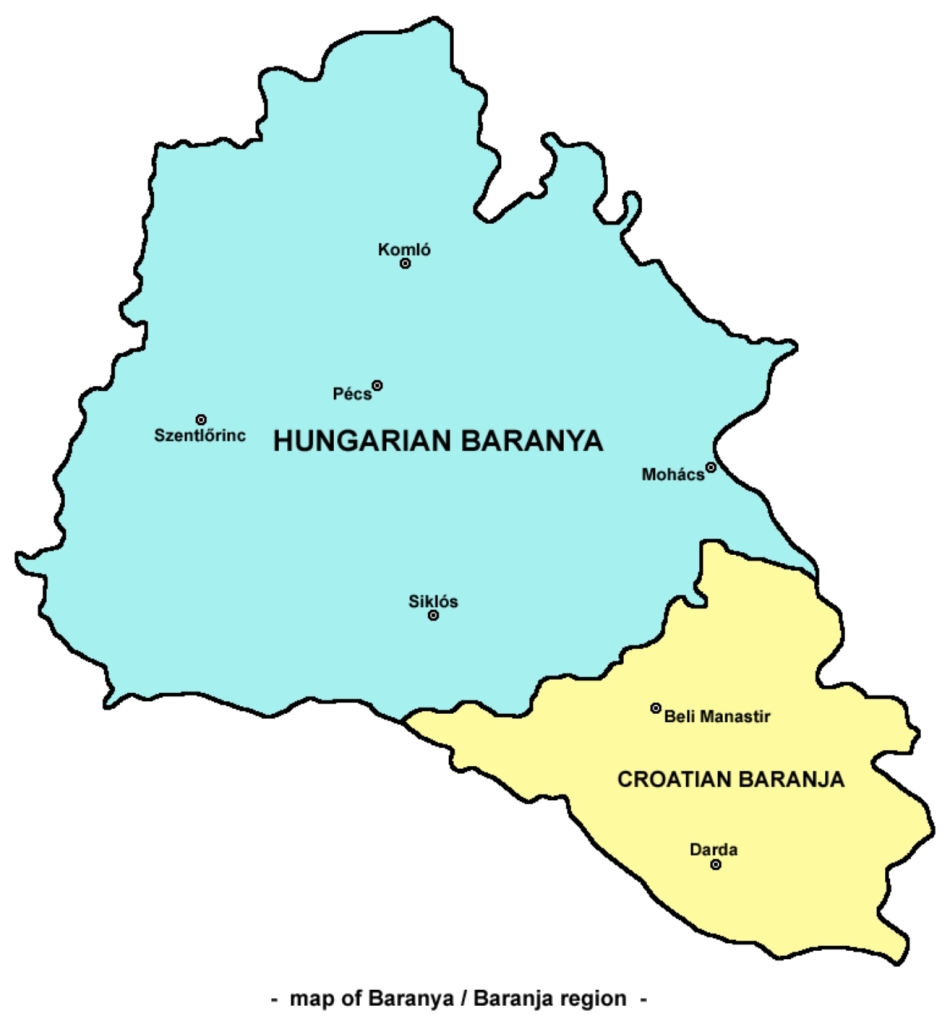
After the dissolution of the Austro-Hungarian Empire, many regions became divided between newly-formed states. Baranya/Baranja was one of those. Baranya was one of the first counties of the Kingdom of Hungary, created in the 11th century. King Stephen I of Hungary founded an Episcopal seat there. In the 16th century, the Ottoman Empire conquered Baranya, and included it into the Sanjak of Mohács, an Ottoman administrative unit with the seat in the eponymous city. After the Battle of Mohács in 1687, Baranya was captured by the Habsburg monarchy, and was included in the Habsburg Kingdom of Hungary. In 1918, the entire Baranya was occupied by the Serbian army and administered as the Baranya-Baja Republic by the newly created Kingdom of Serbs, Croats and Slovenes. By the Treaty of Trianon of 1920, the territory of the county was divided: the south-east of the county was assigned to the Kingdom of Serbs, Croats and Slovenes (later renamed Kingdom of Yugoslavia), and the rest to Hungary. In WWII Hungary occupied and annexed the whole region, but after the war, the 1920 borders were established again. Today, the south-eastern part is ruled by the Republic of Croatia.

Báscka/Bačka is another of those regions that became divided between newly-formed states after the dissolution of the Austro-Hungarian Empire. It is that part of the Pannonian Plain that is bordered by the river Danube/Dunav to the west and south, and by the river Tisza/Tisa to the east. Inhabited from the Neolithic period, it was ruled by many peoples and states, including the Dacians, the Kingdom of the Iazyges, the Hun Empire, the Gepid Kingdom and the Avar Khanate. In the 8th century it has become part of the First Bulgarian Empire. In the 10th century the Bulgarians were defeated by the Hungarians and the territory came under their rule. In the days of King Stephen I of Hungary, two counties were formed in this land: Bács County in the south, its administrative centre being Bács, and Bodrog County in the west and centre, its capital being Bodrogvár. The two countries were later united to form Bács-Bodrog County. In the 16th century the region was ravaged by the Ottomans who defeated the Hungarians at the Battle of Mohács. After the Battle of Zenta and the Ottoman defeat, the Hungarians have re-established the Bács-Bodrog County. After WWI, the Treaty of Trianon defined the new borders between Hungary and the Kingdom of Serbs, Croats and Slovenes (later renamed Kingdom of Yugoslavia) thus dividing the region into two: the major part belonged to the newly-formed South Slav state and the smaller one in the North-West to Hungary. The south-eastern part now lies within Vojvodina, under the Republic of Serbia.
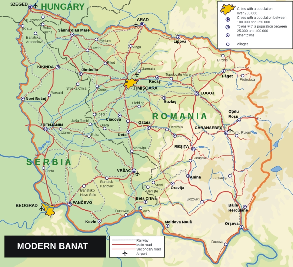
Banat shares a similar early history with Báscka/Bačka. Banat was administered by the First Bulgarian Empire from the 9th to the 11th century, but that control gradually migrated to the Kingdom of Hungary which administered it from the 11th century up until 1552, when the region of Temesvár, of which Banat was part, was captured by the Ottoman Empire and was subsequently organised as the Eyalet of Temeşvar. After the Austro-Turkish War (1683–1699), and under the Treaty of Karlowitz of 1699, northern parts of the Eyalet of Temeşvar were incorporated into the Habsburg monarchy, but the territory of Banat remained under Turkish rule. In the next Austro-Turkish War (1716–1718), the Banat region was taken from the Ottomans and after the Treaty of Passarowitz of 1718, it became a province of the Habsburg Monarchy, but not incorporated into the Kingdom of Hungary. Special provincial administration was established, centered in Temesvár. It remained a separate province under military administration until 1751, when Empress Maria Theresa of Austria divided it between military and civil administration. The Banat of Temesvár province was abolished in 1778, when civilian part of the region was incorporated into the Kingdom of Hungary and divided into counties. The southern part of the Banat region remained within the Military Frontier until the Frontier was abolished in 1871. In 1848, western Banat became part of the Serbian Vojvodina, a Serbian autonomous region within the Habsburg Monarchy. After the Revolution of 1848–1849, Banat was designated as part of a separate Austrian crown-land known as the Voivodeship of Serbia and Temes Banat. In 1860 this province was abolished and most of its territory was incorporated into the Habsburg Kingdom of Hungary. After WWI, the majority of the region belonged to Romania, a minor part to Hungary, and the rest to the Kingdom of Serbs, Croats and Slovenes (later renamed Kingdom of Yugoslavia). The latter is today part of Vojvodina, under the Republic of Serbia
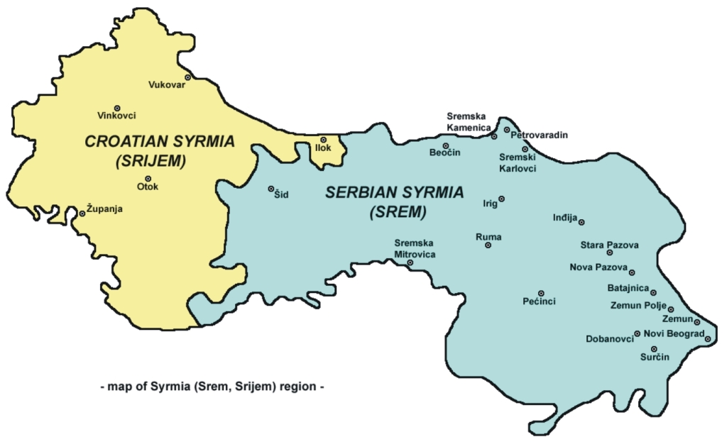
It all began with Syrmia, the centre of Indo-European Vučedol culture between 3000 BCE and 2400 BCE. The Roman conquered Sirmium in the 1st century BCE, the city became the economic and political capital of the Province of Pannonia. Ten Roman Emperors were born in Sirmium or nearby. From the 6th century Syrmia was part of the Byzantine Province of Pannonia. However, in the same century Avars and Slavs conquered the territory, which fell under the Frankish Empire around the year 800. A quarter of a century later Bulgars invaded the region and after that it became a battleground between Hungarians, Bulgarians, and Serbs. In 1071, Hungarians took over the region of Syrmia from the Byzantine Empire, but the latter re-conquered the province after the victory over the Hungarians in 1167. The Byzantine rule ended in 1180, when Syrmia was taken again by the Hungarians. Later, the region was ruled by Serbian sovereigns, either independently or as Hungarian vassals. The Ottomans occupied the region in 1538, but under the Treaty of Karlowitz of 1699 they had to cede its western part to the Habsburgs. In 1745, the County of Syrmia was established as part of the Habsburgs’ Kingdom of Slavonia. In 1848, the temporary Serb autonomous region Serbian Voivodship within the Austrian Empire was established. A year later, Emperor Franz Joseph decreed the creation of the Voivodship of Serbia and Tamiš Banat comprising Northern Syrmia. After 1860, the County of Syrmia was re-established and returned to the Kingdom of Slavonia, which in 1868, became part of Croatia-Slavonia in the Kingdom of Hungary. After WWI, the whole region became part of the Kingdom of Serbs, Croats and Slovenes (later renamed Kingdom of Yugoslavia). After WWII, eastern Syrmia became part of the People’s Republic of Serbia, while western Syrmia became part of the People’s Republic of Croatia, both Republics of the new Federal People’s Republic of Yugoslavia. After the dissolution of Yugoslavia, the border between the two republics became a state border.[5]
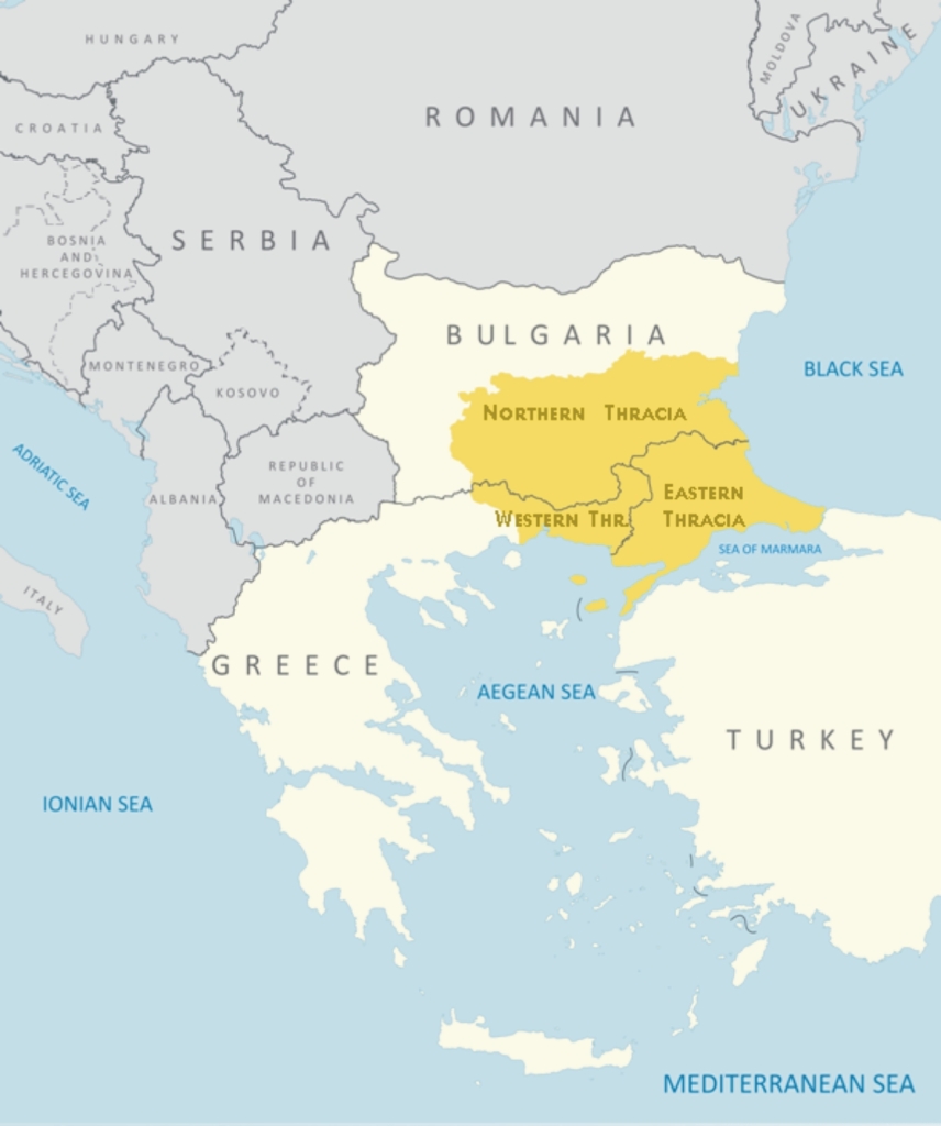
This region is bordered by the Old Mountain[6] to the North, the Black Sea to the East and the Aegean Sea to the South. The Thracians were an Indo-European people inhabiting this part of Europe in the antiquity. Their first permanent state was the Odrysian kingdom in the 5th century BCE, but they were soon subjugated by the Persian Achaemenid Empire. After the Greek victories in the Persian Wars, the Kingdom was free again, but lost its independence to Macedonia in the late 4th century BCE. Rome conquered the region in the 2nd century BCE and turned it into it province of Thrace. Two famous names are connected to the Thracians of old. Spartacus was a Thracian gladiator, one of the slave leaders in the Third Servile War, a major slave uprising against the Roman Republic. Mavrud, on the other hand, is a red wine grape and wine made of it[7], a tradition that dates back to Roman times, if not even before that. The Province of Thrace belonged to the Western Roman Empire, but when that began do fall apart, it came under the jurisdiction of the Eastern Roman Empire. However, with the arrival of (then still Turkic) Bulgarians, the region started to change hands between the Romans (Byzantines) and Bulgarians for the next seven centuries. Thrace was conquered by the Ottomans in 1352 and ruled over it for the next five centuries. The Congress of Berlin of 1878 had Northern Thrace incorporated into the semi-autonomous Ottoman province of Eastern Rumelia, which united with Bulgaria in 1885. Following the Balkan Wars, WWI and the Greco-Turkish War of 1919–1922, the rest of Thrace was divided among Bulgaria, Greece and Turkey. This division is still present, the largest part of Thrace, Northern Thrace being part of Bulgaria, East Thrace belonging to Turkey and the smallest part, West Thrace being under Greek rule.[8]

There are two regions of the same name in Europe. On is located in the North-Western corner of Spain. This is the other one. Galicia is that region “somewhere in Eastern Europe” where WWI was fought on the Eastern front. The region was named after a medieval city with a plethora of names, Галич in Ukrainian and Russian, Halici in Romanian, Halicz in Polish, Галич in Russian, Halytsch, Halitsch or Galitsch in German and העליטש in Yiddish, so it comes as no surprise that the region itself has names galore: Галичина in Rusyn and Ukrainian, Galicja in Polish, Галиция in Russian, Halič in Czech and Slovak, Galizien in German, Galícia, Gácsország or Halics in Hungarian, Galiția or Halicia in Romanian and גאַליציע in Yiddish. It was first mentioned in 1206 Hungarian historical chronicles as Galiciæ. Its eastern part was controlled by the medieval Kingdom of Galicia and Volhynia. In 1253, Prince Daniel of Galicia was crowned the King of Rus. In 1352, the Kingdom of Galicia and Volhynia was annexed by the Kingdom of Poland as the Ruthenian Voivodeship. During the partitions of Poland, it was incorporated into a crown land of the Austrian Empire as the Kingdom of Galicia and Lodomeria. Today the western part of the region belongs to Poland while its eastern half lies in Ukraine.
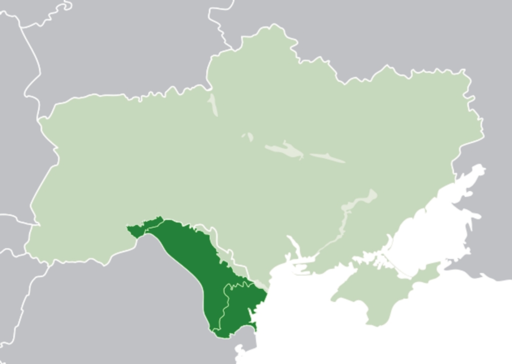
Bessarabia is another region in Eastern Europe between the Dniester River in the east and the Prut River in the west. In the late 14th century, the future Bessarabia was part of the newly established Principality of Moldavia. In the 15th century Moldavia came under the Ottoman rule. After Russia prevailed in the Russo-Turkish War (1806–1812), the ensuing Peace of Bucharest bestowed the eastern parts of the Principality of Moldavia, an Ottoman vassal, along with some areas formerly under direct Ottoman rule, to Imperial Russia, one of the Empire’s last territorial acquisitions in Europe, as the Bessarabia Governorate. After the Crimean War, in 1856, the southern areas of Bessarabia were returned to Moldavia, but Russian rule was restored over the whole of the region in 1878, when the freshly unified Romania was pressured to exchange those territories for the Dobruja region. After the October Revolution in Russia, Bessarabia remained part of the Moldavian Democratic (later: Soviet) Republic. Today, after the dissolution of USSR, two thirds of Bessarabia lies within modern-day Moldova, while the southern coastal region and a small part on its north belong to Ukraine.
There must be many more such regions, not only in Europe, but worldwide (especially where the colonising powers drew borderlines with a ruler!). However, these were the first to come to my mind when addressing the problem of political divisions vs. peoples’ unity, of irrationality vs. logic.
[1] The most blatant example of such politics is the partitioning of the Indian subcontinent into Pakistan, India, and later Bangladesh!
[2] This is a somewhat longer paragraph since the maternal part of my family comes from there. This is the one speaking a Romance language and bestowing me with some Romance genes and my mother tongue.
[3] This is of special interest to me since the part of my family bearing our family name comes from Silesia. In search of our roots, my father established that his greatgreatgrandfather (so my greatgreatgreatgrandfather) was born in what is now the Czech part of the region in 1819. His son, my greatgreatgrandfather, moved over here in the 19th century. The funny thing is that, thanks to the mix of ethnicities up there we do not know to which one they might belong.
[4] My father’s mother was born there, at the extreme West of the region, near the border with Tirol. Her mother came from there to work over here, but when she had to bear her first child, she travelled back to her mother, who knew what should be done. This is the Germanic part of my family. Alas, they never taught me any Germanic language.
[5] Do not let the Croatian prescriptivists fool you. They want the region to be called Srijem, but the native population always called it Srem.
[6] Turkish: Balkan. And it is the only meaningful use of the name. Everything else is either non-existing (the “peninsula” ‒ ask any geographer; the “region”, etc.).
[7] If you visit the region, do not miss to taste it!
According to a legend, during the reign of Khan Krum of Bulgaria in the 9th century, he ordered that all vineyards be destroyed. Later, a lion escaped from its cage and terrorised the city. Then a fearless young man named Mavrud confronted and slew the lion. The king summoned Mavrud’s mother to learn the secret of such courage and strength. She answered that she had secretly saved a vine, made wine, and that this was the source of Mavrud’s bravery. When he heard that, Khan Krum ordered the vineyards to be replanted and both the vine and the wine were names after the young man.
[8] There is a valid reason why I lingered so much on this region. And that has nothing to do with my ancestors, but with a very special person in my life.
